


4 km | 5.5 km-effort
![Trail On foot Staré Město pod Landštejnem - [Z] Landštejnský okruh - Photo](https://media.geolcdn.com/t/1900/400/4832e62c-1f0a-401b-b2b7-a5b710e2b929.jpeg&format=pjpeg&maxdim=2)

Tous les sentiers balisés d’Europe GUIDE+


FREE GPS app for hiking
 SityTrail
IGN / Geographical institutes
SityTrail World
The world is yours!
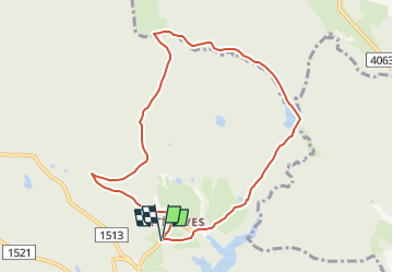
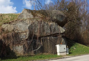
Trail On foot of 8.2 km to be discovered at Southwest, Jihočeský kraj, Staré Město pod Landštejnem. This trail is proposed by SityTrail - itinéraires balisés pédestres.
Trail created by cz:KČT.
![Trail On foot Staré Město pod Landštejnem - [Z] Landštejnský okruh - Photo 1](https://media.geolcdn.com/t/2048/auto/85c9331e-6651-4541-8b38-ef1fdadde33a.jpeg&format=jpg&maxdim=0 "Trail On foot Staré Město pod Landštejnem - [Z] Landštejnský okruh - Photo 1")
![Trail On foot Staré Město pod Landštejnem - [Z] Landštejnský okruh - Photo 2](https://media.geolcdn.com/t/2048/auto/4ecad408-eb10-43e5-9909-816294b41b62.jpeg&format=jpg&maxdim=0 "Trail On foot Staré Město pod Landštejnem - [Z] Landštejnský okruh - Photo 2")
![Trail On foot Staré Město pod Landštejnem - [Z] Landštejnský okruh - Photo 3](https://media.geolcdn.com/t/2048/auto/5a28fcb1-315b-4dd9-b6d7-44bd1a24dff8.jpeg&format=jpg&maxdim=0 "Trail On foot Staré Město pod Landštejnem - [Z] Landštejnský okruh - Photo 3")
![Trail On foot Staré Město pod Landštejnem - [Z] Landštejnský okruh - Photo 4](https://media.geolcdn.com/t/2048/auto/90434c4e-573b-4f9b-8136-d10fa3a2794b.jpeg&format=jpg&maxdim=0 "Trail On foot Staré Město pod Landštejnem - [Z] Landštejnský okruh - Photo 4")
![Trail On foot Staré Město pod Landštejnem - [Z] Landštejnský okruh - Photo 5](https://media.geolcdn.com/t/2048/auto/160b9aa0-29ec-4641-a620-2e8624f9d390.jpeg&format=jpg&maxdim=0 "Trail On foot Staré Město pod Landštejnem - [Z] Landštejnský okruh - Photo 5")
![Trail On foot Staré Město pod Landštejnem - [Z] Landštejnský okruh - Photo 6](https://media.geolcdn.com/t/2048/auto/c288065d-6d4b-478e-8ca8-fc7e117cf6aa.jpeg&format=jpg&maxdim=0 "Trail On foot Staré Město pod Landštejnem - [Z] Landštejnský okruh - Photo 6")
![Trail On foot Staré Město pod Landštejnem - [Z] Landštejnský okruh - Photo 7](https://media.geolcdn.com/t/2048/auto/39fcbf17-2e0b-4074-a49f-000fd18e0e66.jpeg&format=jpg&maxdim=0 "Trail On foot Staré Město pod Landštejnem - [Z] Landštejnský okruh - Photo 7")
![Trail On foot Staré Město pod Landštejnem - [Z] Landštejnský okruh - Photo 8](https://media.geolcdn.com/t/2048/auto/8845d54d-dd97-4925-865d-2ea12e320a30.jpeg&format=jpg&maxdim=0 "Trail On foot Staré Město pod Landštejnem - [Z] Landštejnský okruh - Photo 8")
![Trail On foot Staré Město pod Landštejnem - [Z] Landštejnský okruh - Photo 9](https://media.geolcdn.com/t/2048/auto/c17c935b-a86e-4931-95e5-c73e5cfcee83.jpeg&format=jpg&maxdim=0 "Trail On foot Staré Město pod Landštejnem - [Z] Landštejnský okruh - Photo 9")
![Trail On foot Staré Město pod Landštejnem - [Z] Landštejnský okruh - Photo 10](https://media.geolcdn.com/t/2048/auto/4832e62c-1f0a-401b-b2b7-a5b710e2b929.jpeg&format=jpg&maxdim=0 "Trail On foot Staré Město pod Landštejnem - [Z] Landštejnský okruh - Photo 10")
![Trail On foot Studená - [Ž] Studená - za Vrškem - Photo](https://media.geolcdn.com/t/375/260/dbf7c158-72a2-4a80-bde9-4b16abef1677.jpeg&format=jpg&maxdim=2)
On foot
On foot
![Trail On foot Slavonice - [Z] U Pfaffenshlagu - U Velkého rákosního rybníku - Photo](https://media.geolcdn.com/t/375/260/211566f5-2838-442e-b8a8-1eb4141d961e.jpeg&format=jpg&maxdim=2)
On foot
On foot
On foot
On foot
On foot
On foot
On foot